biodiversity-webmap-template
Simple Biodiversity Web Map
Turn field notes into an online, interactive species-occurrence map in minutes.
Everything runs on a free static site (GitHub Pages) — no server, no database.
![]()
Quick access
- Live map app: https://sanriomisintaro.github.io/biodiversity-webmap-template/app/
- Docs / How-to: https://sanriomisintaro.github.io/biodiversity-webmap-template/docs/
- Get the blank template:
template/ - Converters (online):
- CSV to TXT: csv-to-txt
- XLSX to TXT: xlsx-to-txt
What is this?
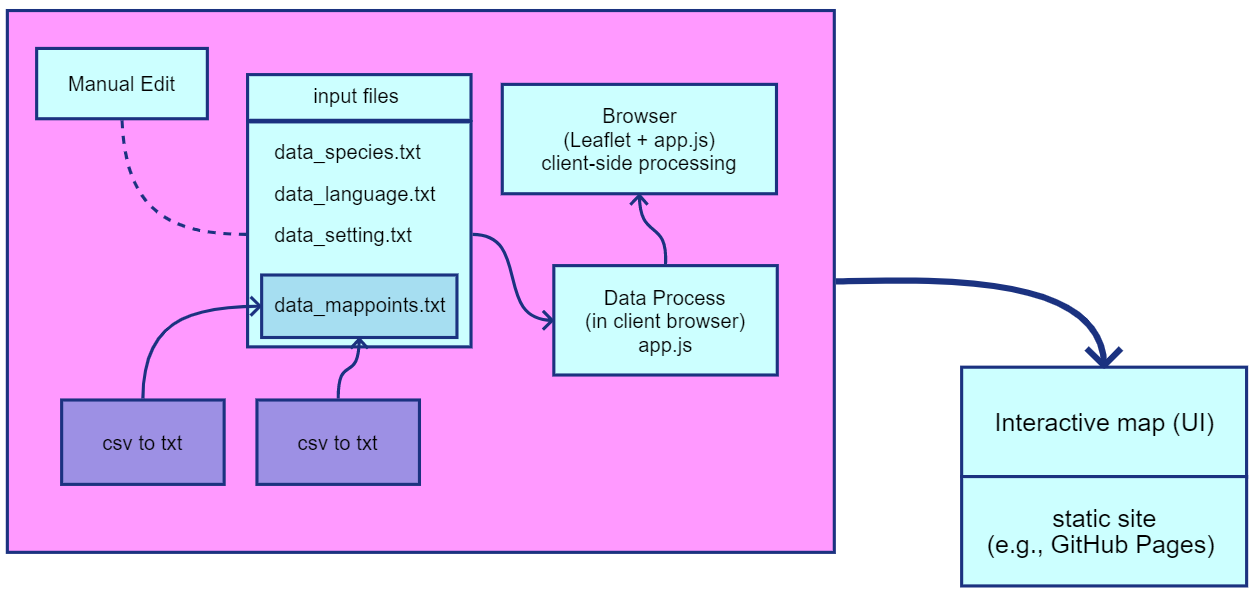
A low-infrastructure method for small biodiversity teams (labs, NGOs, classes) to publish species observations as an interactive web map. The app reads four plain-text files at load time:
data_species.txt– species list and legend infodata_mappoints.txt– occurrence records (one record per line)data_language.txt– UI labels (e.g., Indonesian + English)data_setting.txt– map defaults (zoom, theme, basemap, etc.)
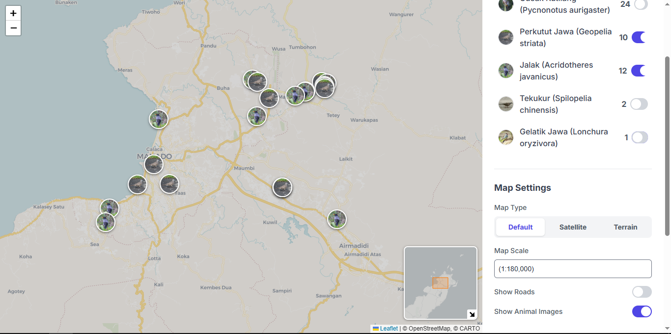
You can edit all four files with any text editor or export them from spreadsheets via the built-in converters. To make something like this:
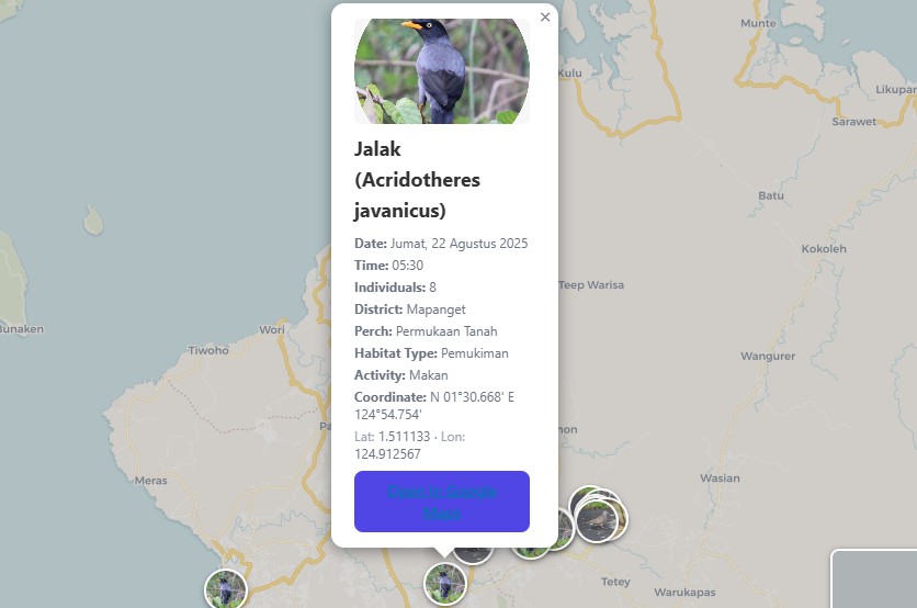
Its also come with detail, if you click on one point to pop up detail for single observation:
Its quite easy to follow, you just edited (or add) datas within four .txt files and its finish, just like that. You can put it in github pages (for free) or in your hosting without more resource (no need for databases) or you can also run in in your local server.
Features
- Interactive map with base-layer switcher (default / satellite / terrain)
- Per-species toggles, count-aware legend, optional photo markers
- Mixed coordinate strings supported (decimal, DMS/DM like
N 01°28.717') - 🇮🇩/🇬🇧 Bilingual UI (e.g.,
[id]and[en]blocks indata_language.txt) - Fully static: works on GitHub Pages; versionable & citable
Repository structure
app/
index.html
assets/
css/styles.css
js/app.js
data/
data_species.txt
data_mappoints.txt
data_language.txt
data_setting.txt
images/ # species photos/icons referenced from data_species.txt
docs/ # how-to guide (served on Pages)
template/ # blank starter you can copy
tools/
csv-to-txt/ # CSV converter (browser-based)
xlsx-to-txt/ # XLSX converter (browser-based)
File formats (quick reference)
app/data/data_species.txt
name | color | image
name: scientific or common name shown in legendcolor: HEX color (e.g.,#377eb8)image: relative path inapp/images/(optional)
Example
Perkutut Jawa (Geopelia striata) | #377eb8 | images/PerkututJawa.jpg
app/data/data_mappoints.txt
date | time | species | count | district | coord | habitat | location | activity
date:YYYY-MM-DD(recommended) or common local formatstime:HH:MM(24h) orH:MM AM/PMspecies: must match anameindata_species.txtcoord:-1.481, 124.846orN 01°28.717' E 124°53.518'- Pipes
|inside text are auto-replaced with/by the converters
Example
2025-08-21 | 06:15 | Perkutut Jawa (Geopelia striata) | 2 | Sario | -1.481, 124.846 | Pekarangan | Pohon ketapang depan rumah | Menyanyi
app/data/data_language.txt
INI-style language blocks + key=value lines:
[id]
appTitle=Informasi Sebaran Burung di Kota Manado
legendTitle=Spesies
details.date=Tanggal
...
[en]
appTitle=Birds Distribution Information in Manado
legendTitle=Species
details.date=Date
...
app/data/data_setting.txt
scale = 12 # initial zoom (city ~12, neighborhood ~15)
theme = light # light | dark
language = local # local=id, translate=en
mapType = default # default | satellite | terrain
showImages = true # true/false | 1/0
showRoad = 1 # 0=show labels/roads, 1=hide labels
Full details and screenshots: see Docs.
How to use
Option A — Start from the blank template
- Download/copy files from
template/. - Fill the four
data_*.txtfiles with your species and points. - Open
app/index.htmllocally (or publish on Pages).
Option B — Convert your spreadsheet first
- Use CSV > TXT or XLSX > TXT online:
- CSV: https://sanriomisintaro.github.io/biodiversity-webmap-template/tools/csv-to-txt/
- XLSX: https://sanriomisintaro.github.io/biodiversity-webmap-template/tools/xlsx-to-txt/
- Move the downloaded
data_mappoints.txtintoapp/data/.
Publish on GitHub Pages
- Push this repo to GitHub.
- Settings > Pages > Deploy from a branch > Branch:
main, Folder:/ (root) - Your site will be at:
https://sanriomisintaro.github.io/biodiversity-webmap-template/
When to use (and when not)
- DO:
- Teaching, outreach, class projects, small NGO/lab datasets (hundreds > few thousands of points)
- DONT:
- If you need multi-user data entry, user accounts, advanced queries, or millions of points > consider a server-backed platform; this app can be a stepping-stone.
Cite / credit
If you use this template in a publication or report, please cite the repository and (if available) the archived release DOI. (not ready yet to cite)
License
- Code: MIT (permissive; see LICENSE)
- Your data/images: choose an appropriate license (e.g., CC BY 4.0).
- Please keep required basemap attributions visible in the map UI.
Sensitive species
If needed, generalize or mask coordinates before publishing (e.g., round to 0.01° or remove precise sites). Please never publish the exact locations of sensitive taxa. We mean it, especially for endangered and protected taxa.
Troubleshooting
- Problem: No points on map, do:
speciesvalues indata_mappoints.txtmust matchnameindata_species.txt. - Problem: Broken images, do: check the path (e.g.,
images/Jalak.jpg) and filename case. - Problem: Settings ignored, do: ensure
key = valueformatting (no extra characters). - Problem: Local file won’t load do: some browsers block local fetches. If you have python, serve locally:
# in the repo root python -m http.server 8000 # then open http://localhost:8000/app/- if you dont have python, use any local web server.
Acknowledgements
Built with lightweight web tech (vanilla HTML/CSS/JS). Map tiles from OpenStreetMap / imagery providers as configured in the app.